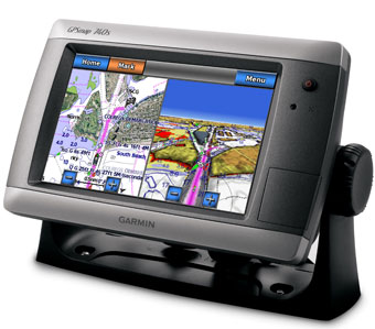
Garmin® Widens its Horizons, Introduces 7-inch Stand-Alone Touchscreen Chartplotters
-
in Garmin
-
Hits: 2375
 Garmin International Inc., a unit of Garmin
Ltd. (NASDAQ: GRMN), the global leader in satellite navigation, announced the GPSMAP® 700 series – the first
touchscreen controlled stand-alone marine chartplotters with radar
capability and built-in sonar at an affordable price that’s easy to
justify for any boat or budget. The GPSMAP 700 series was announced in
conjunction with the Tullet Prebon London International Boat Show,
January 8-17, 2010, and will then tour internationally at the
Düsseldorf, Seattle, Atlantic City and Miami Boat Shows in the coming
months.
“Our touchscreen technology is recognized throughout the industry
for its performance and ease of use, and we’re excited to further
expand our product line with these new panoramic displays,” said Dan
Bartel, Garmin’s vice president of worldwide sales. “In a class of
their own, these products offer a whole new perspective on fingertip
navigation and bridge the gap between the entry-level boater and the
luxury yacht customer.”
The GPSMAP 740 comes preloaded with
detailed offshore maps for all U.S. coastal areas, including Alaska and
Hawaii and Explorer Charts® data of the Bahamas. Garmin also
introduced the GPSMAP 720, which shares the same advanced features and
is designed for markets outside the United States. For sonar
capability, Garmin also offers the GPSMAP 740s and GPSMAP 720s combo
models, which feature a built-in 1kW capable sonar transceiver that can
clearly define fish targets and terrain features as far down as 2,000
feet to keep you apprised of what’s happening under the surface.
All of Garmin’s new chartplotters in the GPSMAP 700 series feature a standard radar port that lets you connect with any Garmin GMR™ series marine radar for target scanning on your chartplotter screen. Whether you’re adding radar now or in the future, you’ll enjoy the convenience of “plug-and-play” installation, as well as the power, range and high-definition targeting of Garmin’s proven radar offerings. These units are the first non-network radar-capable units offered in Garmin’s marine product line up, and offer the perfect solution for the cost-conscious mariner who wants to take advantage of radar capabilities without the network price. In addition, these new units offer full NMEA 2000 connectivity and make it easy to monitor engine, fuel, autopilot, weather and other onboard sensor data via the chartplotter.
Like the other Garmin touchscreen marine products, these units feature a sophisticated and elegant “flat-screen” physical design that complements today’s modern boats. Boasting a sleek 7-inch super-bright, waterproof (IPX7 standards) touchscreen display, the GPSMAP 700 series offers unprecedented extremes of brightness for daytime readability with super low-level dimming for optimum night vision. With a built-in high-sensitivity GPS receiver, these new chartplotters are the perfect navigation solution for a single station vessel, and with their small footprint, can fit onboard your vessel where other larger units cannot. The built-in GPS receiver provides installation location flexibility, and therefore can also effectively serve as the back-up navigation station on a larger yacht.
For superior situational awareness, mariners can also load the new GPSMAP 700 plotters with an optional BlueChart® g2 Vision® SD card to navigate with a clear moving-map representation of the boat’s position. With BlueChart g2 Vision, mariners can also take advantage of the Auto Guidance feature which suggests the best routes to follow. In addition, g2 Vision features true MarinerEye view above water or a FishEye underwater perspective – both in three dimensions. And for help in navigating tricky harbors and channels – or locating marinas and resorts – g2 Vision cards offer a growing database of aerial reference photos.
