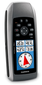
High performance marine handhelds - GPSMAP 78
-
in Garmin
-
Hits: 2274
 Garmin International Inc., a unit of Garmin
Ltd. (NASDAQ: GRMN), the global leader in satellite navigation, announced the next generation in marine handhelds: the GPSMAP 78 series. These rugged units are a great fit in Garmin’s best-selling lineup of color marine handhelds - and they float! Featuring a bright 2.6-inch LCD color display with built-in basemap and high-sensitivity GPS receiver with HotFix®, the GPSMAP 78 series takes recreational navigation to a new level. All three models are waterproof, include a built-in microSD™ card slot for loading additional maps and have a dedicated MOB (man over board) button. In addition to the standard feature set on the GPSMAP 78, the 78s version adds a 3-axis compass, a barometric altimeter and a worldwide shaded relief basemap. The GPSMAP 78s also offers wireless route and waypoint sharing with other compatible units.
Garmin International Inc., a unit of Garmin
Ltd. (NASDAQ: GRMN), the global leader in satellite navigation, announced the next generation in marine handhelds: the GPSMAP 78 series. These rugged units are a great fit in Garmin’s best-selling lineup of color marine handhelds - and they float! Featuring a bright 2.6-inch LCD color display with built-in basemap and high-sensitivity GPS receiver with HotFix®, the GPSMAP 78 series takes recreational navigation to a new level. All three models are waterproof, include a built-in microSD™ card slot for loading additional maps and have a dedicated MOB (man over board) button. In addition to the standard feature set on the GPSMAP 78, the 78s version adds a 3-axis compass, a barometric altimeter and a worldwide shaded relief basemap. The GPSMAP 78s also offers wireless route and waypoint sharing with other compatible units.All three units support Garmin Custom Maps and BirdsEye™ Satellite Imagery. Garmin Custom Maps is a free and simple process that transforms paper and electronic maps into downloadable maps for your compatible Garmin GPS. BirdsEye Satellite Imagery is a subscription-based service that allows you to see aerial views of your destination.
Product Features and Specifications
• High-sensitivity, WAAS-enabled GPS receiver and HotFix
• Floats
• Rugged, waterproof (IEC 60529 IPX7)
• Worldwide built-in basemap with shaded relief
• microSD card slot for optional mapping
• Wirelessly share thumbnails, routes, tracks, waypoints and geocaches between compatible units (78s)
• Bright 2.6” LCD sunlight readable color display (160 x 240 pixels)
• 3-axis compass, provides accurate heading even when the unit is not held level (78s)
• Barometric altimeter tracks pressure changes to pinpoint your precise altitude and to assist in monitoring weather (78s)
• High-speed USB interface(78s), Full-speed USB (78) and NMEA 0183 (GPSMAP 78 series)
• Up to 20 hours of battery life, battery type: 2 AA (not included) NiMH or Lithium recommended
• Weight: 7.7 oz. with batteries (218.3g)
The GPSMAP 78 series will be available from June.
